Articoli

Thales Alenia Space Italia chooses GEO-K technology for SAR data analysis

Thales Alenia Space Italia chooses GEO-K to realize new platforms for COSMO-SkyMed SAR data analysis.

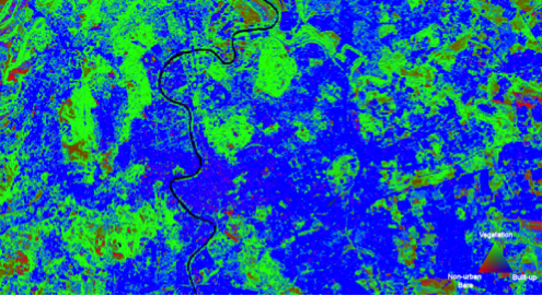
The agreement signed on 22 March 2016 requires the creation of a first suite for automatic analysis application for oil spills, ship survey, coastline extraction and land cover classification. All of this will be detected by neural network technology developed by GEO-K over the past years.

Both GEO-K and TAS-I wish the just-signed agreement may be renewed in view of new potential available with COSMO Second Generation Data.


GEO-K takes part to the study for super-classification of multispectral data

GEO-K participates to the study for the super-classification of Landsat Multispectral products. The study will be published on the IEEE Journal of Selected Topics in Applied Earth Observation and Remote Sensing in the next period.

What is super-classification?

With it, we consider the ability to discriminate the different “materials” that form a single pixel signal. Often these materials are different and composite on the Earth’s surface. With this approach, we can ultimately increase the capability of satellite instruments in terms of spatial resolution.

The methodology proposed by GEO-K and the Earth Observation Laboratory of the University of Rome Tor Vergata is based on advanced techniques exploiting Neural Networks.

The first results obtained by the team were presented at the URBAN 2015 Remote Sensing Joint Event in Losanna, Switzerland.

URBANFLUXES at Rome 2015 Science Symposium on Climate

GEO-K took part at the Rome 2015 Science Symposium on Climate poster session, on November 19-20, with a contribution to URBANFLUXES project.

The recently launched Horizon 2020 project URBANFLUXES investigates the potential of EO to retrieve urban energy budget components, focusing on the anthropogenic heat flux. The main challenge of this project is the innovative exploitation of the Copernicus Sentinels synergistic observations to estimate local scale spatio-temporal patterns of the anthropogenic heat emission in cities. These EO-based spatially disaggregated estimations contain valuable information for both the urban planning and the Earth System Science community.


Urban Imagery for thermal behavior of cities at JURSE 2015

Earth Observation (EO) systems and the advances in remote sensing technology increase the opportunities for monitoring the thermal behavior of cities.
Several parameters related to the urban climate can be quantified from EO data products, providing valuable support for advanced urban studies and urban climate modeling.
The study has been presented at the last JURSE congress in Lausanne. In this study, remote sensing techniques are applied to derive quantitative information necessary to identify possible zones with homogeneous thermal characteristics (Local Climate Zones LCZ).

Parameters like the pervious and impervious surface fraction, the surface albedo, the building density, the mean building/tree height, and the sky view factor are quantified for a study area in Crete, Greece. The EO products are then used under a methodological framework to map the LCZ.

Individual EO products, as well as the LCZ classification itself, is useful to urban climate modeling and studies to assist in planning and decision making.

Future research includes the investigation of more urban parameters extraction with EO data, with the ultimate goal of developing a methodology adaptable to the Sentinels.